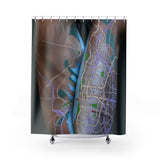
Created from the original hand-drawn plausible fictitious map art of David Nuttall @Artimaps.
Add some mappy flair to your bathroom and get lost in the larger-than-life details, no magnifying glass needed.
.: 100% Polyester
.: One side print
.: Hooks not included
Map Details for Human Terrain 25 - set in United States
This map shows roads, rail lines, water, parks and woodland areas using the natural shape of the body as the base terrain for the hand-drawn temporary map. This map was intended to depict the contrast between rural areas (torso) and a large lake-front city (thigh) which included research into rural Wisconsin and the city of Chicago. The roads are depicted in three colors with the lowest category being drawn with a metallic silver which captured the light differently, depending on the pose.


